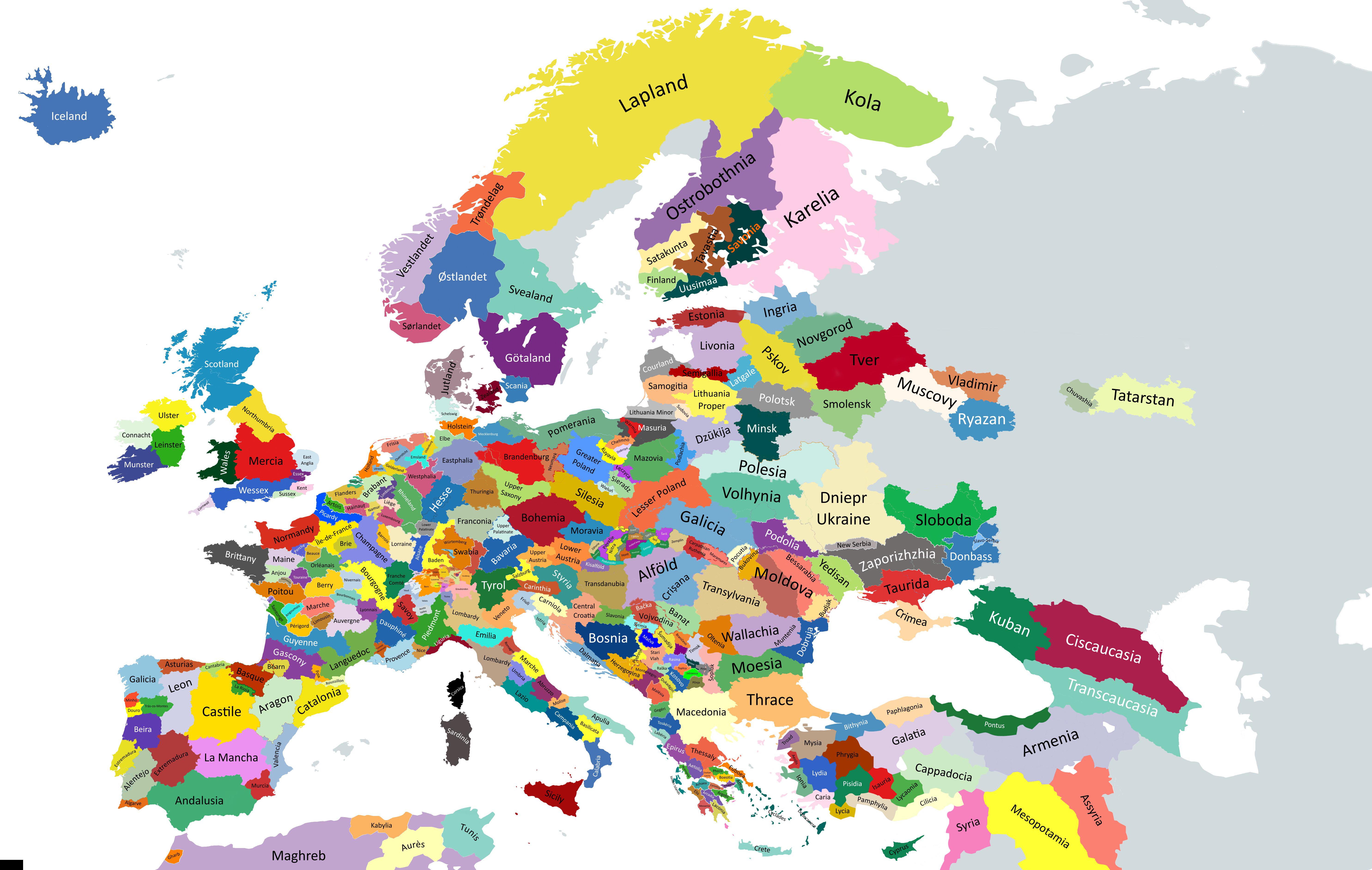
Source: https://old.reddit.com/r/MapPorn/comments/1fdij5t/historical_regions_of_europe_beta_version/
Seems to be quite a few litigious points, especially
- Lombardy / Tuscany
- Slovakia
- Galicia in Poland
- Scotland
- Etc.
I'll follow up on this thread and post the updated version if the author updates it
Additional input from the author
Here is the explanations comment
The main reference maps are here.
This map is based on geographical/historical/cultural regions division of Europe. The base canvas that has been used is Europe-Detailed from MapChart and it sucks because every country is overstretched with some parts like Germany and the Balkans being highly deformed. The overstretched Scandinavia was so unworkable I replaced it with HOI4 MapChart (it was already too late when I discovered MapChart has Paradox Interactive maps). If I make a final version, I will probably use HOI4 provinces as my base canvas because they provide enough fragmentations and countries are not that much deformed.
Since this map is intended to be used for studying History, I tried to focus on historical regions (which are often cultural regions too). When I couldn't use historical regions because it was too complex or because of a lack of data, I resorted to geographical regions.
So, now here are some details about the regions I chose to display :
- Sweden is not finished. Here is the map I planned to use as my reference for Sweden.
- I am still struggling to understand if the borders of the federations composing current North Caucasia are historical borders or if they were imposed by Moscow after some forced ethnic migrations. So I chose the easy way and displayed the geographical regions.
- Germany's regionalism is hell because of the HRE. So I assumed that people who are interested in the HRE should rather use more specific maps instead of mine. The regions displayed on my map come from a mix between dialect maps and political entities that have been around for a long time. Brandenburg and Upper Saxony are overstretching on their western part because I didn't know what to do with Sachsen-Anhalt.
- Russia is largely blank because of the lack of data. From what I understood, people in Russia use either big cities or uezds to refer to a specific location. Using uezds would be the most accurate solution but I am not familiar enough with russian geography to work with such a fragmented Russia so for the time being, I decided to display current oblasts that approximately correspond to either one of the main principalities of the Kievan Rus.
- The Balkans map is mostly based on geographical regions. I am still unsure for Alföld. Gorica is not displayed because it is too small. Baranya is not displayed because the Croatian-Hungarian-Serbian border is already too complex. The coastal region of Toskëria should be Myzeqe but I decided to not display it for now because it was rather small.
- For Switzerland (whose key has been rendered unreadable by the compression) I kept the current county division
If you want to make an improved map or a variation map, feel free to use this unfinished map.
Note : If you have some remarks, I think it would be better to write them on a separate comment and not reply to this one to avoid creating an unending thread of replies.
Note 2 : Feel free to provide more detailed maps of specific regions of Europe, it may save some time for people struggling to find what they want.

For Scotland, if we are to approximately match the time period and granularity represented in England: