29
you are viewing a single comment's thread
view the rest of the comments
view the rest of the comments
this post was submitted on 13 Oct 2024
29 points (96.8% liked)
Climate - truthful information about climate, related activism and politics.
5149 readers
460 users here now
Discussion of climate, how it is changing, activism around that, the politics, and the energy systems change we need in order to stabilize things.
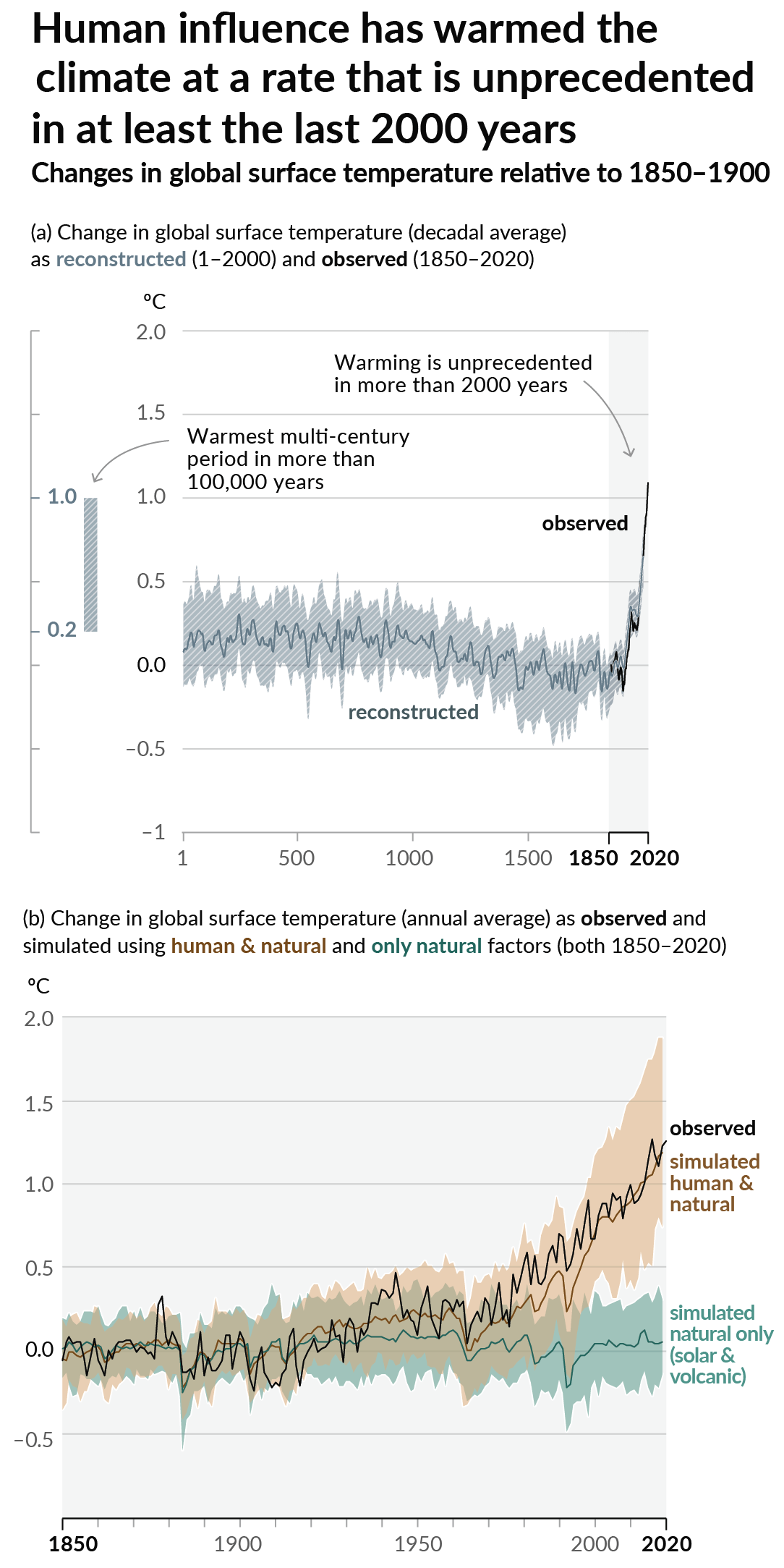
As a starting point, the burning of fossil fuels, and to a lesser extent deforestation and release of methane are responsible for the warming in recent decades:
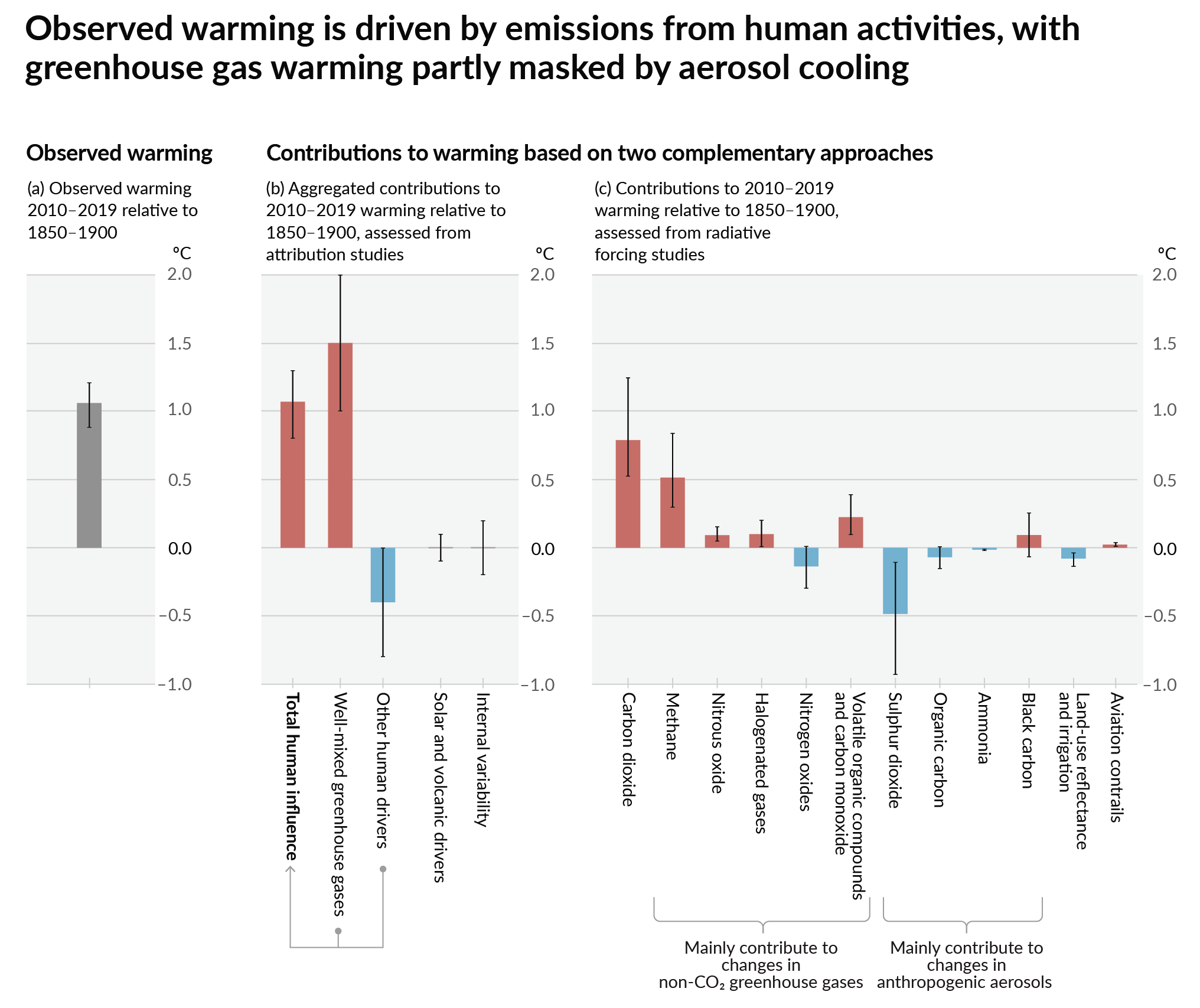
How much each change to the atmosphere has warmed the world:
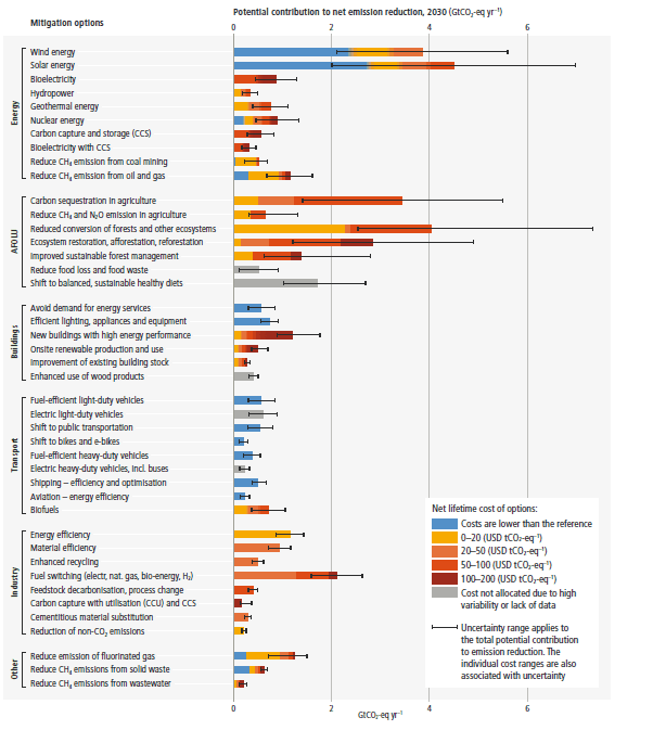
Recommended actions to cut greenhouse gas emissions in the near future:
Anti-science, inactivism, and unsupported conspiracy theories are not ok here.
founded 1 year ago
MODERATORS
The problem here isn't that models are wrong or inadequate, but that FEMA, for political reasons, has based its maps and risk estimates on historical averages, and those don't adequately capture the change we've had, or relatively low-probability events.
Ahh, you're talking the risk assessments and the associated floodplain maps. So yes, many of the maps are decades out of date, despite the legal requirement they keep them updated.
Those maps, by nature, are based on historical data but then use projections to assign future risk assessments. My point was that while we may have consensus on increases in global temperature, what that means for specific areas is almost impossible to forecast in a way that wasn't true before. For example, we know that major ocean currents may be in danger because of global warming, but we don't know when or if that will happen and exactly what exact effect it will have on a specific parcel of land, and that effect may be quite acute.
Between extreme weather events, changes in land use, etc., the unprecedented nature of the changes we're facing and the complexities involved mean that no matter how accurate the previous data and no matter how bleeding edge the climate modeling we use, any new maps are going to be much more unreliable than they've been previously.
And because those maps are expressly tied to the National Flood Insurance Program, that means potentially billions being lost because the map was wrong. Of course the map is wrong now, but that's unfortunately how bureaucracies think - better to be wrong because of inaction rather than sticking your neck out.
The real problem going forward is that the very fundamental idea of being able to map weather risk is a fiction. It would be far better to assume most areas are going to see extreme flooding and then judge how resilient the area is to that flooding and make policy decisions based on that. Even with perfect maps and models, people in the next 50 years need to understand that there will be no climate havens and that it's not a question of if you'll experience an extreme weather event but when.