jay2

joined 1 year ago
[–] jay2@beehaw.org 5 points 3 weeks ago

You may want to opt out of those services. Even LinkedIn seems to know it's got potential to be a flaming hot train wreck, apparently to the point where they desire no responsibility for the public messages made by their machine that they own, train, and qc.

[–] jay2@beehaw.org 3 points 3 months ago

Ahh, I was mistaken. Libre is open source.

[–] jay2@beehaw.org 22 points 3 months ago* (last edited 3 months ago) (6 children)

Having used autocad for nearly 40 years, I will say they stick it to their customers pretty fiercely. I still use 2010 with 3rd party software to get it to run on win10 at home. I do a lot of solid models and assemblies as well as technical 2D drawings and renderings.

FreeCAD is impressive, but it lacks an easy to use interface. NanoCAD and LibreCAD are not open source but are free and are both better 2D alternatives.

Edit: LibreCAD is open source.

[–] jay2@beehaw.org 1 points 5 months ago

The Dorothy Eady always stuck with me. It's fairly well documented.

After falling down the steps at home, she nearly died. When she came back to life, memories were unlocked of a prior life in Egypt in which she was a priestess in an egyptian temple. She would go on to have a very successful career working in Egyptian antiquities.

As for the really really weird shizz, anyones guess. I try not to just arbitrarily cut someone down, but it's unlikely there would be proof of her having a conversation to an ancient diety.

[–] jay2@beehaw.org 4 points 5 months ago

They trip all over themselves just to seemingly not use the phrase "open source" huh?
[–] jay2@beehaw.org 2 points 9 months ago

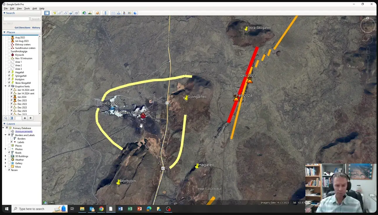
Professional geologist Shawn Willsey posted a graphic of the approximate location of the newest fissure on his livestream. This fissure and flow is not likely to be a threat to the town of Grindavik, but it is a threat to both the blue lagoon and the powerplant.


The lava is flowing again after a third volcanic eruption. The placement appears to be a good ways to the north of Grindavik as of yet. Multicam view.

[–] jay2@beehaw.org 16 points 9 months ago (7 children)

I built a PC for my little sister in 2007. She was starting college and didn't have a computer. It totaled 2805 and some change, custom built through Antares Digital (When you know, you Lili). These were all top of the line components (Asus M2N32-WS PRO, Amd athlon64 X2 AM2 5200, Corsair Memory). Not a cheapy system in its day.

Three nights before I was to deliver it to her, I completed all of the setup, had all the software ready to go, even setting up a custom theme for her (We were both metalheads). My folks said that she would need a printer/fax/copy/scanner as well, so last minute, I ended up buying an HP 5610 at target for 192 dollars.

The HP instructions didn't say that if you connected the cable between the printer and the PC before you had installed the drivers, the printer would not mount as a device. In fact, it would never connect to that PC ever again. Apparently, it ruined the registry until you reformatted and reinstalled the OS.

To be fair, the manual did say to install the drivers first, then the cable, but this was not the norm back then and they didn't really emphasize it in any way, nor did it mention that you were about to be FITA big time. Had to scramble to completely reformat the drive, reinstall all the software... Essentially, starting over from a blank slate and getting done in 2 days for delivery to her dorm on move in day. It did connect second time around.

I wrote them an angry letter regarding the poor deployment, but of course I never heard back from them. Never bought another HP for myself or anyone else ever again. I go out of my way to encourage people to not buy anything from HP. If I happen to be somewhere and see someone looking at an HP printer, I'll just approach them, introduce myself, and tell them my story to discourage them from buying it.

[–] jay2@beehaw.org 1 points 9 months ago* (last edited 9 months ago)

The aftermath of the January 14 2024 volcanic eruption which has now officially been declared to be over.
The Map

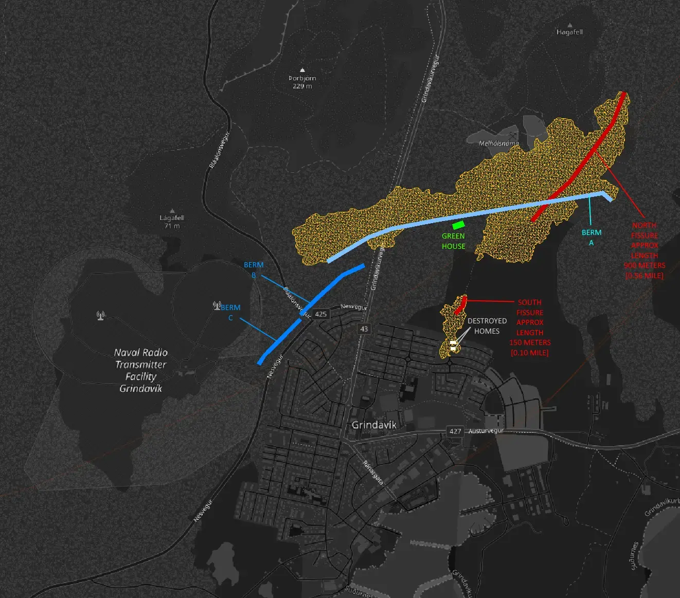
This is a combination of Agust Gudmundsson's Satellite Map and the 2D quake map. I used Autocad to import each image and then known features to match the scales and orientations, but it's still an approximation. Additionally, the satellite image is greyscale and low resolution so the perimeter of the lava field gets hard to discern in some areas with little to no color contrast.

The Fissures and Lava Fields

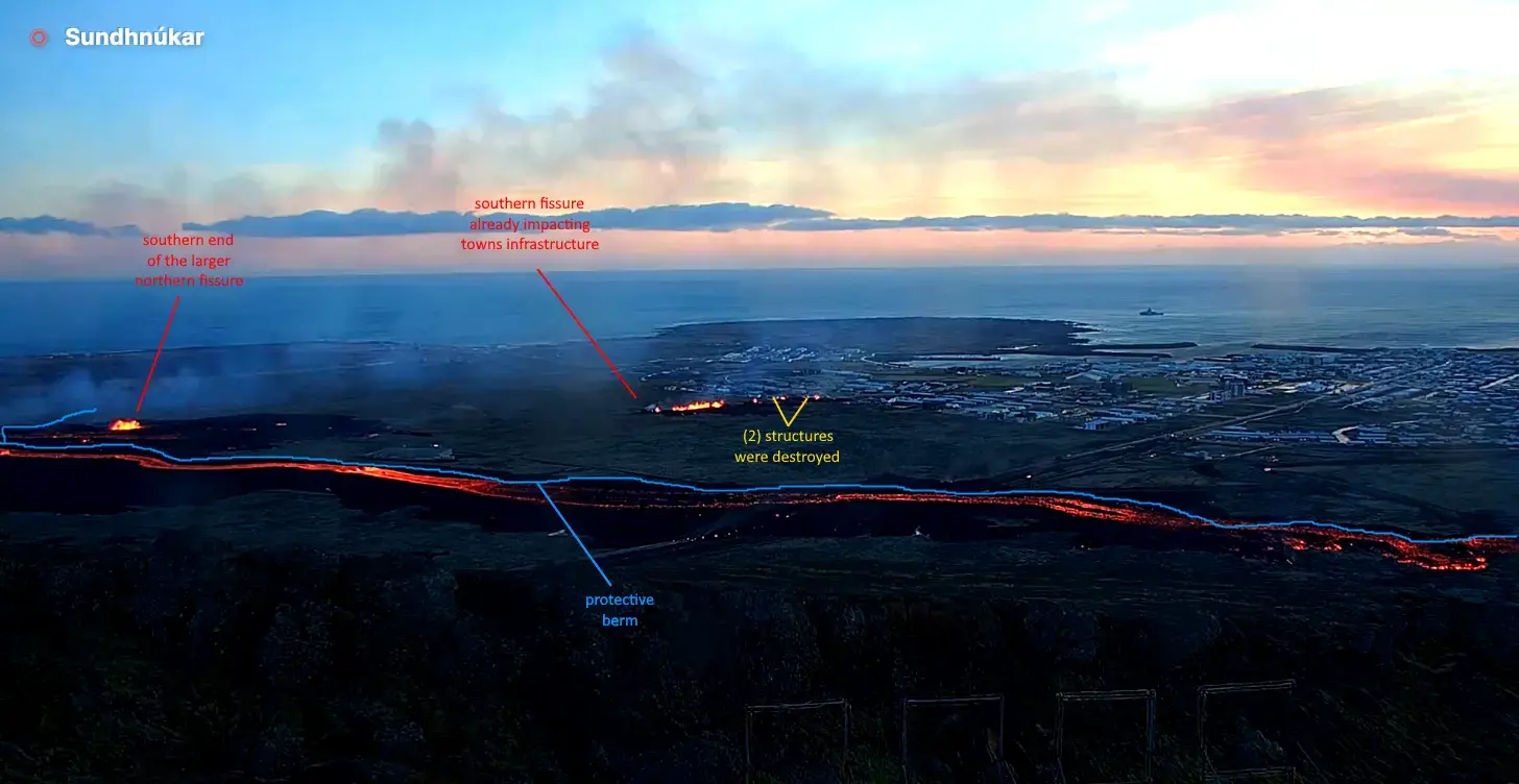
The two eruptive fissures (north[900m] and south[150m]) are shown in red. It ejected quite a bit of lava, but the experts say they were lucky that the eruption was as weak as it was. The new lava fields from each are in orange. The initial fissure to the north grew in its size as the eruption continued and extended itself underneath the original berm. This extension and the area where the berm crossed the highway allowed lava behind the ber.

The southern fissure was completely unexpected and it was heartbreaking to witness. While it released a smaller amount of lava at a lower pressure than the north, but due to its proximity to the village, it was enough to destroy at least (2) homes.

The Berms

The berms are shown in blue, both the original (lite blue) and the two new additional ones (medium blue).

The original 10-15 meter high [32-48 foot] berm held up strong and most likely saved the village from much more damage. However, it was not completely effective. A small portion of the berm at the highway had been left open for travel until the day of the eruption when emergency crews plugged it last minute.

During and since the eruption, the emergency crews have built (2) new berms on the west side of Grindavik to further deflect lava and protect the village.

The Infrastructure

The town is still under evacuation order due to the uncertainty of future eruptions and the dangers inside the village due to subsidence and instability.

Electricity seems to be back on in town.

The geothermal pipeline that runs tandem (a few meters west) to the north-to-south highway and was destroyed by lava. This is significant in that this supplies Grindavik it's most abundant heat source, hot water. Homes that were not in harms way are still going to have moderate damage due to frozen pipes. [Edit Jan 21 2024] It was reported that just yesterday emergency crews bypassed the destroyed section of pipe restoring water both hot and cold.

Two of the reported three homes that were destroyed by lava are shown in white. The north home does not appear on many maps. It was reported to be a new home that was yet unoccupied. The south home was occupied and appeared to be a complete loss. I am still unsure about the third home.

The greenhouse, shown in green, survived seemingly undamaged thanks the the original berm. It was reported to have had all of its equipment removed prior to the eruption.

I heard a report that the local government is probably going to be able to offer Grindavik residents a buyout for their homes and property but all I can find is a report that it may be possible.

250 abandoned sheep were reported to have been rescued and removed on Tuesday Jan 16.

The Next Chapter

The future of Grindavik is not looking so good. The data seems to point towards yet another eruption, and likely within the next few weeks.

The Svartsengi GPS Station is near the power plant (north of Grindavik). This is the region where the experts suspect the ultimate source of the magma. It is feeding the magma chamber under Grindavik which is where the eruptive fissures from both December and January formed. It will take months or years of inactivity for this to cool and plug itself. While the system is fed, the pressure will increase. As the pressure builds, the chances of the magma moving or erupting increase. There is no real way known to man as to what exactly is going on down there.
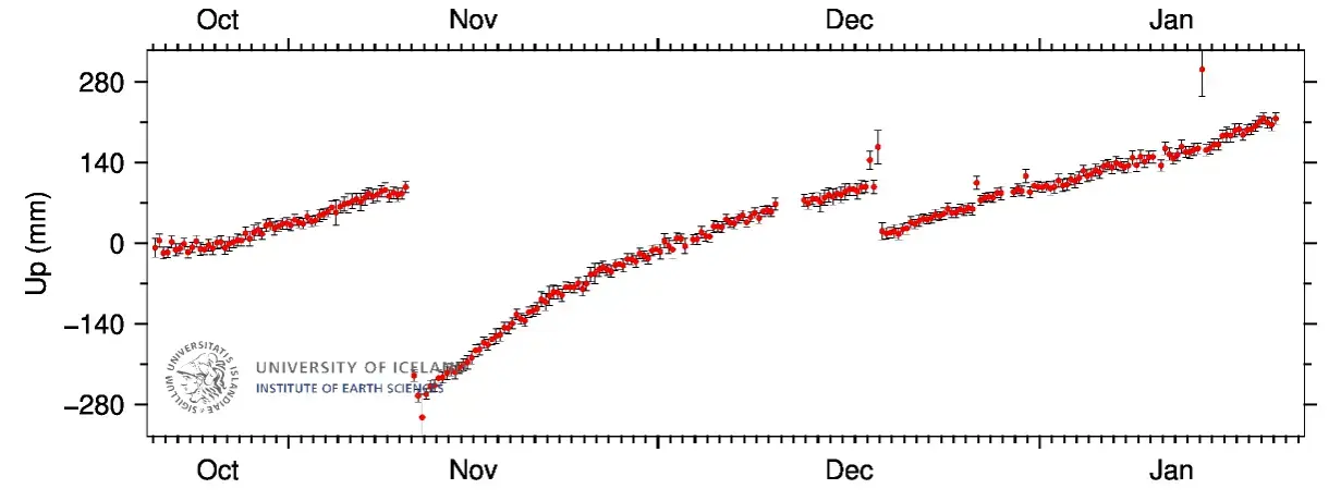
Earthquakes have been very quiet in the area which is to be expected after the balance of pressure. They have ramped back up through the week but are still low in frequency, size and depth. During the eruption, there were numerous mini-clusters of earthquakes near Grindavik (Locations with a high concentration of earthquakes). One of these locations ultimately became where the southern fissure erupted. There were (2) other mini-clusters south of that fissure well inside of Grindavik. Both of these areas of mini-clusters are above the magma chamber and could be places of a future eruption. With the damage to the area, it could just be stress related fractures.

Send hope and prayers to the great and brave people of Grindavik.

[–] jay2@beehaw.org 1 points 9 months ago (1 children)

Not sure, but I suspect rates just went up. I'm just a science geek from North Carolina that does refractory for a living, hence my interest.

I watched as the first home caught fire. It was brutal to watch it. I did read that it was not occupied. It does not appear on a lot of maps. The second home though that went up was occupied. This was someone's home, someone's place of solace. Children were raised here. Memories were rooted here. It was a total loss. I read that (3) homes in total were destroyed by fire due to the 100km southern fissure's lava output, though I only saw (2). I am unsure about the third. I am unsure where the third one was.

Numerous other homes are going to be severely damaged though. Hot water is actually quite abundant I hear due to the geothermal power plant. The lavaflow from the 900km main fissure was mostly deflected by the berm away from Grindavik, but the berm untimately guided it to the pipeline. Geographically speaking and considering the timeframe they had to work in, I don't think it could be helped.

I understand that hot water is a primary source of heat since it's a cheap and abundant byproduct of the powerplant. It's what you're also bathing in at the Blue Lagoon Hot Springs. Now devoid of heat, I would suspect that many homes are now going to suffer damage from frozen/busted pipes.

My heart still goes out to the incredible people of Iceland. I'd like to think I could cope with an event like this, but I'm fairly certain I would puss out. Icelanders are far more metal than I.
[–] jay2@beehaw.org 1 points 10 months ago

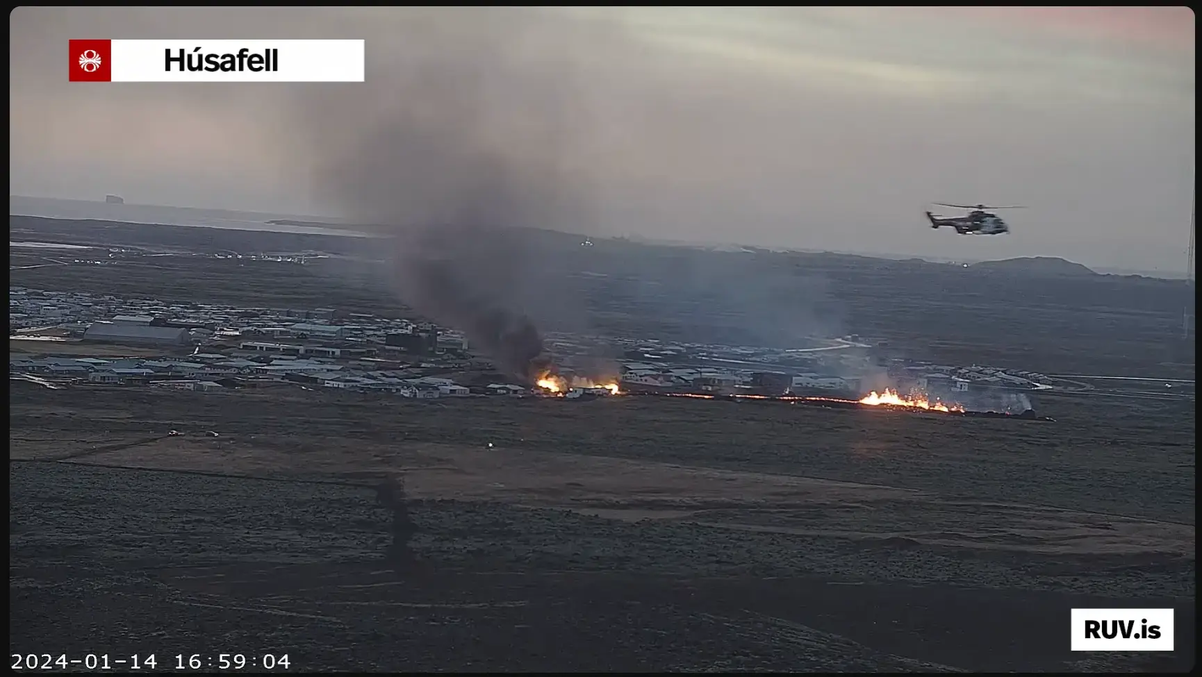
Either a third fissure has opened (there is a mini-cluster of larger magnitude quakes in his area), the second fissure has extended into town, or more homes are catching on fire. It's getting hard to tell which due to the volcanic gasses (White), smoke (Black) and just the darkness of winter.

There was a another mini-cluster of earthquakes further to the south edge of town as well. With it's proximity to the sea it will cause a severe amount of damage.

I feel this is a historic event. I'm also a refractory designer, which places this squarely in my realm of interest, but it's heartbreaking to have to watch in slow motion. This would be very cool if it were not for the human element present in these conditions.

[–] jay2@beehaw.org 2 points 10 months ago (1 children)

I look at the most recent activity and suspect that either a new fissure has opened in the town proper or the southern fissure has lengthened. There exists a mini cluster of larger earthquakes in this area. The best case scenario is that this is a new structure on fire. All three scenarios are rotten-a-f. It is getting hard to tell due to gasses, smoke and darkness.
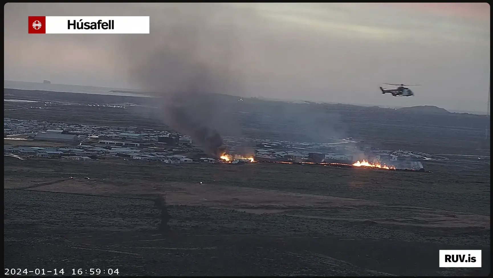
That is most likely a RUV news helicopter in the foreground. It's footage may be available shorty. You can also read their english blog here. Drones are once again banned 4km from town.
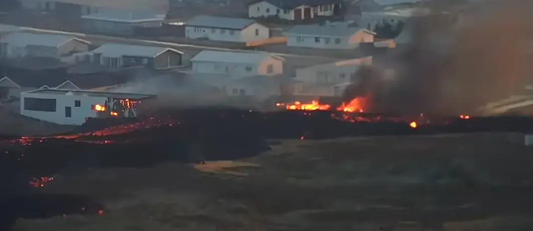
 

Iceland erupted again this morning at 7:57am Grindavik Time. The eruption was captured in real time. It again is a northwest linear fissure and is located west of Hagafell and a bit south of the prior eruption site in December.

While the locals had built a huge rock berm to protect some of it's infrastructure, the fissure formed and spread underneath the berm, circumventing its protection. Everyone has been evacuated, though there are reports that despite being told not to bring any previously evacuated animals back to town, some may not have obeyed and now the animals may be locked up and in harms way.

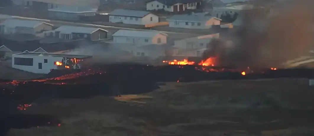
Additionally, a second fissure opened on the north edge of town. You can see this in real time on Professor Shawn Willsey's live update from early this morning. This southern fissure is much smaller but is much closer to town. It has spewed forth enough lava that it has now contacted and destroyed (2) houses along the towns northern edge. It was one of the worst scenarios that could happen. This is likely just the beginning, and could signal the end of Grindavik as it now exists.

The northern fissure has ejected a huge amount of lava but most was deflected and contained by the berm. It has now breached the berm at the highway, which they plugged as best they could early this morning. All things considered, it was quite wise of them to do this. The greenhouse would likely have been destroyed already, and much more lava would now be heading towards Grindavik, which is downhill from both eruption sites.

.

A closeup of the initial damage from the new active lava flow

.

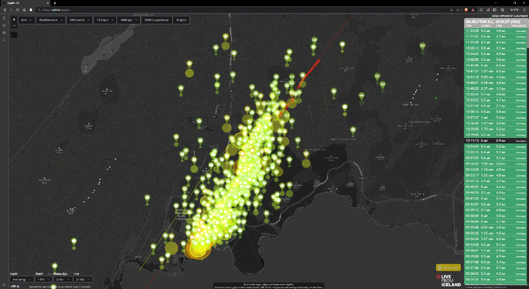
Earthquake map as of this morning. The quakes give you an idea of how big the magma chamber under the town is.

.

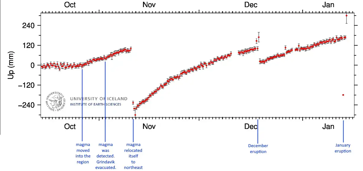
GPS Elevational Data over the campaign of this eruption

.

This is a very serious and dire situation. Whatever god you acknowledge, pray for the town of Grindavik to be spared. My heart goes out to the brave people of Grindavik.

[–] jay2@beehaw.org 2 points 10 months ago

A closer view of the initial damage. This could very well be the beginning of the end for Grindavik.

It noteworthy to mention that the town has been evacuated and the people are not in harms way, but this was likely someones home. My heart breaks for you folk.
 

The magma chamber threatening the grindavik area has erupted again just before 8:00am.

Live Webcam


For a week now, the town of Grindavik [Google Earth] in Iceland has been ravaged by underground volcanic activity. It's a fishing town situated southwest iceland along the coast. It's on the Reykjanes peninsula which is the youngest area of Iceland formed 2000-3000 years ago from volcanic activity.

In early November, uplifting occurred to the northwest of Grindavik. On Thursday November 9th, larger quakes were recorded to the northeast of Grindavik. These earthquakes spread to the southwest through the town and out into the ocean. At the same time, a noticible depression was now present.

Scientists concluded that a new magma chamber had formed. It was 9.5 miles long at ~1/2 mile below the surface [15 kilometers at 800 meters]. A large portion of it was centered directly underneath Grindavik's western edge, its residential district.

A state of emergency was declared and the entire town (excepting emergency workers) was evacuated. This displaced approximately 1% of their entire population. There was a brief window where some people got back in to gather some personal effects\pets\etc., and only to the eastern part of town, but conditions have worsened and there is no access.

Presumably, the initial flow caused the landmass the town sits on to raise up. The magma then retreated (maybe back northeast) leaving a void and causing subsidence. This shifting (and the subsequent hundreds of earthquakes a day) have practically sealed the towns fate already. Cracks have become fissures and houses are skewing. Their infrastructure and their very ground is taking serious damage. It is a disaster of epic proportion.

Sadly, the worst may be yet to arrive. Everyone is still very unsure about specifics regarding magma turning into lava, but the general scientific concensus is that an eruption is both likely and imminent. When's and where's are largely unknown, though it if breaches under the ocean, things get even more complicated. A seafloor breach would create a more unpredictable and explosive scenario. The model I saw gave high probability to a series of vents northeast of Grindavik (the Hagafell region?) as the most likely, but the local folks seem to think that Grindavik itself is the most likely place for an eruption. Others say that it will sink into the sea.

There are live broadcasts of the area that feature multiple camera angles and live earthquake mapping. A more detailed scientific explanation from geology professor Shawn Willsey.


A barrage of hundreds of earthquakes, including two exceeding a magnitude of 5.0 and at least seven topping 4.5, rattled Iceland’s Reykjanes Peninsula on Friday. The seismic swarm suggests the eruption of an area volcano in the hours or day ahead and has prompted the Icelandic Meteorological Office to declare a Civil Protection Emergency Level.

The Fagradalsfjall volcano is in Iceland’s southern peninsula region, about 25 miles southwest of Reykjavik, the country’s capital. A number of tremors have shaken the city, and the famed Blue Lagoon geothermal spa in Grindavik has been closed. It was initially unclear whether Fagradalsfjall was responsible for the increased seismic activity or whether an eruption was brewing elsewhere within the Reykjanes volcanic system.

Shortly before midnight local time, all of Grindavik was asked to evacuate. At 11:30 p.m. local time, the Meteorological Office warned that volcanic fissures could open near or within the town.

“Based on how the seismic activity has evolved since 6 PM today, along with results from GPS measurements, there is a likelihood that a magma intrusion has extended beneath Grindavík,” the office wrote.

Experts believe that a magmatic dike may have formed directly below the town. Dikes are sheets of magma that flow through existing fractures in rock or generate a new crack. The largest volcanoes may contain hundreds of dikes.

A Code Orange — or a Level 3 out of 4 on the universal ground-based volcano alerting scale — has been declared, raising concerns at Keflavik International Airport, which sits just northwest of the seismically active region.

The region has experienced intermittent eruptions since 2021, yet the incipient eruption will probably be markedly more intense.

“The amount of magma involved is significantly more than what was observed in the largest magma intrusions associated with the eruptions at Fagradalsfjall,” the Meteorological Office said.

The office had warned Friday afternoon that earthquakes were located about two miles northeast of Grindavik, with the fault slips occurring about two to three miles below the ground. Earthquakes crept toward the community of 3,300 around sunset.

“The seismic activity has moved south towards Grindavík,” the Meteorological Office said.

“The signs that can be seen now … are similar to those seen on the eve of the first eruption at Fagradalsfjall in 2021, and are very similar to the seismic activity that was measured about a month before that eruption,” the office had cautioned in an earlier update. It had previously estimated that it would take several days for magma to reach the surface and the imminent eruption to begin.

What are supervolcanoes and should we really be worried about them?

Already, the quaking has ruptured roadways. It appears that up to three inches of uplift, or vertical movement of the ground, has occurred near the volcano.

A total of 295 earthquakes of magnitude 3.0 or greater had been detected in the previous 72 hours, with upward of 90 percent of those occurring in the past day.

While Iceland is tectonically and volcanically active, the region around the Fagradalsfjall volcano had lain dormant for over 6,300 years until December 2019. That’s when a flurry of earthquakes, including two that reached magnitude 5.6, rattled the peninsula. Then on Feb. 4, 2021, a magnitude-5.7 earthquake caused minor damage to homes. Six weeks later, on March 19, the volcano erupted, with a roughly 2,000-foot-long fissure started spewing lava.

The fissure was later named Geldingadalsgos, representing a possible new shield volcano — a broad volcano with gently sloping sides — and it attracted widespread tourism. Several other fissures opened in April, but only one remained active in May 2021. Another eruption from a separate fissure of Fagradalsfjall took place on Aug. 3, 2022.

Then this past summer, in early July, a new eruption began near Litli-Hrutur, also part of the Fagradalsfjall volcano. It was about 10 times as big as the first two eruptions. It diminished by Aug. 5.

Live triple cam feed here.


I really dislike the modern look of RPG sprites. They all have a blended look of cartoon and cutsie. A double-sized head with gigantic pie-sliced eyes and crazy stupid weird colored hair. I really can't stand it. I could go on for hours about how I dislike them. Suffice to say I'm seeking alternatives.

Anyone know of any artists that make and sell a different look? I don't mind dropping a few bucks for art if it's worthwhile. Its very frustrating that everything I find has gigantic heads with more @$#%^ eyes. It doesn't need to be lifelike but I would want it to be better proportioned.

Anyone know of any good software for making the animated spreadsheets yourself via posing a 3D model? I tried Easy Pose last month with low success, though it was my first attempt and arguably there's a learning curve here. There is a disconnect between the style of the clothed sprite and the style of my other tiles (world, furniture, etc) so I must redo them. I'm considering using them as a base underlay to create my own from scratch. It's going to be a butt-load of work and am unsure how it will turn out. Would hate to do all that with low success only to find out later there is a better way.

Also monsters/enemies would be something additional, though I don't mind the RPGMaker enemies anywhere near as much as the horridly awful actor/character sprites. I would not like to see a huge difference in style between monsters and characters.

As for my specifics, I'm kind of looking to end up with a 96x192 top down rpg sprite with idle and animated walking. Side view battle would be nice but not necessary. Other animations are a bonus but can live without. I intend to strive towards a a base model character that I can swap out layers on to create numerous permutations of featured characters.

I'm using the RPG Maker Unite engine which is similar to other RPGMaker products in their design style for the sprites. I can do a fair amount of pixel art myself so even like a base model body that I can expound upon would be something to consider. My base tile size is 96x96.

As a note, I am also a 3D cadd designer by trade. Working in Blender or other cadd software isn't too much of a problem for me, though I run AutoCAD and Inventor mostly and am still largely new to Blender. I often know what I want to do, but have to research how I get the software to comply. As such, I am usually just exporting out of AutoCAD to an intermediary format and importing that into Blender. I do all my own touch ups in paint dotnet, and am pretty proficient with it as well.

Just looking for recommendations from someone who may have been there before. I'm no worse off if I get no replies. It's also notable to mention that I'm just a hobbyist doing this for fun. I certainly lack a lot of knowledge that a true video game designer would have. I can use tips if you've been there and got em.


Ink (2009) [ Action/Drama/Fantasy ]

A monster steals a little girl's soul and the forces of light intervene to try and save her.

While it's not defined as a horror movie, it is a very dark fantasy with a lot of the elements. Great story, good acting, good special effects and it leaves you feeling pretty good when the credits roll.


Mayhem (2017) [Action/Comedy/Horror] [UNRATED]

Steven Yeun
Samara Weaving

A virus spreads through an office complex causing white-collar workers to act out their worst impulses.

This was not only a great movie but a great ride as well. I would describe it as a brutal Action/Horror movie. The plot kind of unfolds along the way culminating into a very satisfying revenge-fueled ending.

view more: next ›