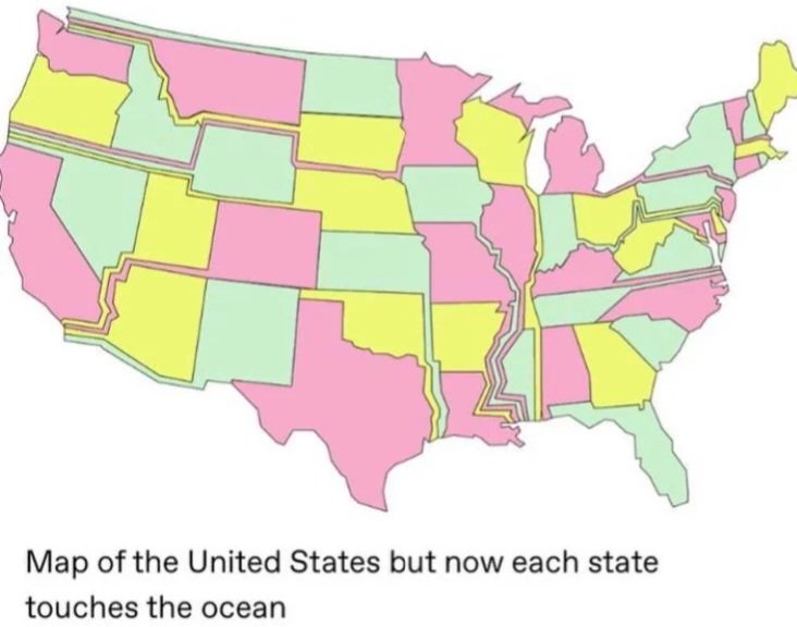
Least gerrymandered election
Funny
General rules:
- Be kind.
- All posts must make an attempt to be funny.
- Obey the general sh.itjust.works instance rules.
- No politics or political figures. There are plenty of other politics communities to choose from.
- Don't post anything grotesque or potentially illegal. Examples include pornography, gore, animal cruelty, inappropriate jokes involving kids, etc.
Exceptions may be made at the discretion of the mods.
Whoever made this underestimates the shore of a Great Lake, I see. Ohio and Michigan already have beaches.
But those aren't oceans
Look man, I'll get sick if i drink from Lake Erie same as if i drank from the ocean. Works for me
In some parts of Michigan you don't even have to drink out of the lake. You can just drink out of your sink and get sick
No salt and no sharks, and all the beachy goodness.
As someone who grew up on the Great Lakes who now lives on the Pacific, they are not comparable.
You can't get surfer hair without saltwater.
Minnesota and Wisconsin too. And with the Eerie canal, they all have access to the ocean
If we're just gonna start counting whether or not our waterways have access to the ocean, then pretty much every Midwestern state counts by way of the Mississippi's drainage basin. 32 states have tributary rivers that find their way to the Mississippi, and then to the Gulf.
Incidentally, I love the detail in this map where the state of Mississippi no longer touches the Mississippi River, and the city of New Orleans is apparently divided across the states of Iowa, Missouri, Illinois, and Arkansas.
After this map, Ohio no longer has a Great Lake Beach.
They’ll just be left with a salty proboscis through Mary’s West Virginia.
The image says nothing about beaches, it's just the title of the post.
And no shot Chicago is moving into Wisconsin without a civil war first.
Yeah, Chicago here. Fuck the ocean, give me back my lakeshore.
Edit: actually, if I'm still physically in Chicago, I guess it doesn't matter overly much whether it's Chicago, IL or Chicago, WI, though I think Illinois needs us more, from a political perspective.
Yeah we don't need it, keep your east coast beaches.
I'm fine with this as long as the little strip is referred to as the state's tentacle
The "proboscis like appendage"
Sounds like prime real estate
You can now drive through Minnesota for an entire day and not leave.
Grand Portage, MN to Brookings, OR is 35 hrs on the fastest route and 37hrs on the route closest to the map.
That would be three long days of driving for someone not cannonballing it.
Feels weird that MN doesn't follow the Mississippi to the gulf. But it's probably better this way
Great, now everyone has more beach than poor NH
Washington state is like helpppppp
Split Seattle like that and you would turn those four other states blue, lol.
at the expense of flipping washington itself, though. lots of nutjobs in the portion that remains.
Not sure the folks in Bellingham are going to be too keen on joining North Dakota. Lynden might be cool with it though. Idaho claiming Spokane would be a hilarious (and tragic) turnabout. Would Okanogan even notice becoming part of Montana? The state capitol stays at least, but losing the Seattle metro region would be a major blow to the economy. Looks like Vancouver is now Washington's largest city... And it's just a subset of another state's metro region!
United States
*offer not valid in Hawaii and Alaska.
No no I want to see Hawaii landlocked now.
California gets stretched to surround both of them.
"What, you went to Hawaii for vacation? That flyover state?"
Oklahoma is now very jealous of North Dakota having a longer “finger”
Minnesota's tail > both
Long Island is gone.
Not complaining though.
Every other state had to borrow its long.
Lol. Ohio trades 300 miles of shoreline and multiple islands along lake erie (to michigan of all people) so it can drive way the hell over to a crowded jersey beach. No thank you.
Excuse me, Crowded Ohio beach.
The IT wire management guys would have neatly routed the western states into a single oceanic backhaul access corridor.
What about Alaska and Hawaii, don't they get to touch the ocean? /s
I think Minnesota has the longest drive to it's beach. Anyone see a longer drive?
Ah yes the United States of Bosnia
This would be pretty cool. But would it have unintended negative consequences?
Nah pretty sure this will end well
Shit, my dumbass thought those were canals bringing the ocean to the states, and I only now see it's the states being stretched to the oceans lol
Right there with ya bud 😂
All states count as "US border" now, so every citizen falls under the complete and unrestricted authority of the DHS.
iirc, customs offices and international airports count as 'borders' so pretty much the whole of the lower-48 already 'qualifies'
