182

I understand that weather on TV can’t be hyperlocally accurate. But a weather app on my phone has my exact GPS coordinates. Why can’t it tell me exactly when a rain cloud will be passing over my location?

It’s gotten to the point where I just use precipitation maps to figure out my rain chances for the day.

The hourly forecast is mostly useless because it’s not a chance % but a % of the area that will be raining.

top 50 comments
sorted by: hot top controversial new old
[-] viking@infosec.pub 82 points 3 months ago* (last edited 3 months ago)

Weather apps don't do real time analytics, but show you the forecast some nearby weather station has calculated. Whether that's based on current data or a couple hours ago depends on the exact provider they use. And hardly anyone of those are done by actual humans, it's aggregated statistics.

If you look at precipitation maps, you are doing that forecast by yourself based on cloud movements and local knowledge, something no machine-generated forecast can do as good.

Plus, there's usually one weather station covering a large area, so hyperaccurate predictions would have to be made just for you - which simply costs to much.

[-] halcyoncmdr@lemmy.world 23 points 3 months ago

Nearby is so highly dependent on where exactly those are located, and what they're connected to (some are handled by local volunteers that have hardware that reports periodically as opposed to being operated by an agency directly). Various apps don't all connect to the same data sources.

Official reporting locations may not actually be close to you and weather can be highly localized. A mile can make a massive difference in weather in some regions, and the official recording location for the city is 10 miles away.

load more comments (4 replies)
load more comments (1 replies)
[-] captain_aggravated@sh.itjust.works 57 points 3 months ago

I am a pilot and flight instructor. I took a full year of meteorology at ERAU. Most weather forecast products presented to the general public are completely worthless, and we really should run "AccuWeather" out of business.

The temperature number they show you for what it is "now" was probably taken by the AWOS at the closest municipal airport to your location. If you've ever noticed like a car GPS reporting weather from three towns over and not the one you're in right now, it's because the town you're in right now doesn't have a nearby airport or it doesn't have an AWOS.

10-day forecasts are generated by tarot cards and have no basis in reality. Actual aviation weather forecasts seldom reach out beyond 24 hours.

Your best bet for getting a complete understanding of the weather is to start by looking at the GOES satellite imagery, ie actually look at the Earth from geosynchronous orbit and look at the clouds. You know those maps with the blue lines with triangles on them and red lines with half circles and big blue Hs and big red Ls? Those are called Prognostic charts, those map where high and low pressure systems and fronts are. Look at one of those and compare them to the satellite images. Then look at Doppler radar imagery, which shows where precipitation is. Look at what it's been doing for the last few hours, and then you can get a good sense of generally what the weather is going to do in the next few hours. Beyond that, not even God knows because the prick hasn't decided yet.

[-] FuglyDuck@lemmy.world 14 points 3 months ago

It amazes me how some people seem to go through life not realizing weather is fundamentally chaotic.

Like, even if all you do is look out a window from time to time…

load more comments (7 replies)
[-] ABasilPlant@lemmy.world 3 points 3 months ago* (last edited 3 months ago)

Just out of curiosity, why do you dislike AccuWeather?

[-] captain_aggravated@sh.itjust.works 6 points 3 months ago

My main beef with them is they take data from the public National Weather Service and package it for profit, and they're backing proposed legislation that would prevent the NWS from distributing their weather data directly to the public.

Other than that, most of what AccuWeather does is make the pretty weather maps for the TV stations, and most of the way they make them pretty is by making them less accurate, complete and precise. To a pilot, for whom weather information is a critical safety tool, an AccuWeather product is a bit like a traffic light covered in a half inch thick layer of Spongebob stickers.

The NWS is already trying to measure and predict the giant ball of chaos that is the Earth's atmosphere with probably fewer tools than they'd like, and AccuWeather takes that data and makes it worse so that it's prettier for TV.

In conclusion, fuck AccuWeather.

load more comments (1 replies)
[-] vrighter@discuss.tchncs.de 34 points 3 months ago

just because it knows where you are, doesn't mean it has measurement equipment there.

[-] Etterra@lemmy.world 7 points 3 months ago

Especially because in some places, with more or less frequency, it can be raining somewhere and not raining a mile from there, and randomly just interspersed around randomly. I hear Florida is exactly like that and it makes them extremely hostile towards meteorologists.

load more comments (1 replies)
[-] rc__buggy@sh.itjust.works 21 points 3 months ago

Just stand under the weather station, then it's exact

[-] CountVon@sh.itjust.works 19 points 3 months ago

MinuteCast from AccuWeather does exactly this. It looks at your location, looks at radar data for storm systems approaching your location, and estimates when precipitation will start at your location and how intense it will be. It's generally pretty accurate, with some limitations. It seems to be pretty good for consistent rainstorms but it can get tripped up by pop-up thunderstorms, where the radar track can go suddenly from no rain to downpour. It doesn't make predictions more then 2-3 hours out because past that timeframe it's not easy to predict if weather will continue on its current track or change direction. Even with the limitations, I use it all the time. Mostly to tell if I should take the dogs out right away, or if I should wait an hour or two.

load more comments (2 replies)
[-] linearchaos@lemmy.world 17 points 3 months ago

Darksky could do it back in the day more or less. you'd get messages that it would rain in about 15 minutes and stop in the next 30.

Thing is, precep maps don't work everywhere. You're probably in a location like me where a thick front rolling through will almost always bring rain. If you get into warmer tropical climates, rainclouds will just poof out of nowhere and drop rain on your ass while other crazy fronts will pass over with nothing but some dark clouds.

[-] friend_of_satan@lemmy.world 10 points 3 months ago

Apple bought darksky, and Apple Weather now has that feature that notifies you before it rains.

[-] c0smokram3r@midwest.social 10 points 3 months ago

Apple butchered the integration. I fucking hate the stock iOS weather app 😤🤬

[-] linearchaos@lemmy.world 9 points 3 months ago

yeah, i don't run apple so they don't exist for me anymore.

[-] friend_of_satan@lemmy.world 9 points 3 months ago

That sucks. It is so frustrating when large companies shut down widely used public APIs.

[-] Talaraine@fedia.io 6 points 3 months ago

I can't really describe to you how angry I was when that shit went through. Like... I knew it was ridiculous to get so angry but, I LOVED THAT FREAKING APP.

[-] solrize@lemmy.world 6 points 3 months ago

Apple bought darksky

OMG I had no idea. Ouch.

[-] Curious_Canid@lemmy.ca 8 points 3 months ago* (last edited 3 months ago)

Oh, yeah. Not only did they take it away from all Android users, they also killed the API that let other apps access it. I wrote an open-source tool that made Dark Sky data available to Wear OS watch faces. It worked beautifully for several years, until Apple killed it.

The worst of it is that was my second attempt. An earlier version of the same tool worked with Weather Underground data. Then IBM bought it, changed the API completely, and priced it so that only business could afford it.

I haven't had the heart to try a third time.

Sorry, every once in a while I'm overcome with the need to whine about it.

[-] juststoppingby@lemm.ee 3 points 3 months ago

Just putting it out there, but the National Weather Service has a free API here.

load more comments (1 replies)
[-] sramder@lemmy.world 3 points 3 months ago

LOL. Thanks for your service. I think you should let yourself off with time served ;-)

[-] Curious_Canid@lemmy.ca 2 points 3 months ago

I appreciate that. :-D

load more comments (3 replies)
[-] dirtySourdough@lemmy.world 17 points 3 months ago

Weather prediction at point locations is extremely challenging to get right because we simply can't observe and make predictions for every single square inch of the earth. Many weather models are run on grids with boxes about the size of a few kilometers at the smallest scale, which means that any physical process in the atmosphere that is the size of that box or smaller won't be represented well by the model.

Specifically on your point about clouds passing over your location, cloud and precipitation formation is even more challenging. Clouds and precipitation form due to atmospheric processes ranging from hundreds of kilometers all the way down to micrometers, which practically means the weather models are making an educated guess (albeit a very good one that is informed by scientific research) about when and where clouds will form. And when a model does predict a cloud, it will cover an entire grid box.

Finally, I saw you made a comment about how machine learning should improve forecasts, and in fact it does! But the weather community is still working on data driven models (as opposed to models that solve physical atmospheric equations), and most of them are run by private companies so their output is not free. As these data driven models get better, it may be possible that they will be able to make predictions at scales less than a kilometer.

[-] TacoEvent@lemmy.zip 6 points 3 months ago

This is a really thoughtful and educational answer. I learned a lot from this. Thank you!

[-] givesomefucks@lemmy.world 13 points 3 months ago

But a weather app on my phone has my exact GPS coordinates. Why can’t it tell me exactly when a rain cloud will be passing over my location?

Because they've never been able to do that...

When they say "50% chance of rain", it doesn't meant there's a 50/50 chance it rains where you're located

It's that for the broadcast area, about half is gonna get rain.

[-] folekaule@lemmy.world 19 points 3 months ago

Unless I misunderstood what you said, that's not it either. 50% chance of rain means exactly that: according to their forecast models, there is a 50% change it will rain. Snopes did a writeup of this.

[-] WolfLink@sh.itjust.works 13 points 3 months ago* (last edited 3 months ago)

Key word “in the given forecast area”.

The statement “there’s a 40% chance of rain at any given point at any given time in the forecast area/period” is an average over both area and time.

Many different actual distributions of rain could result in that average, including a 100% chance of it raining 100% of the time in 40% of the are or a 40% chance of it raining in 100% of the time in 100% of the area, and a 100% chance of it raining 40% of the time in 100% of the area. Real distributions are typically messier than that.

load more comments (7 replies)
[-] independantiste@sh.itjust.works 6 points 3 months ago

It's that for the broadcast area, about half is gonna get rain.

Isn't that virtually the same thing as a 50% chance of rain at my position though?

load more comments (4 replies)
load more comments (1 replies)
[-] dan1101@lemm.ee 10 points 3 months ago

Look at a weather map with animated radar overlay. You will often see precipitation approaching and can predict how soon based on its speed and heading.

load more comments (1 replies)
[-] FauxPseudo@lemmy.world 9 points 3 months ago* (last edited 3 months ago)

I know any in my case. I'm in a black hole of info. The nearest weather station is over 30 miles away and it's not remotely accurate for my location because of terrain changes between here and there. There isn't even a weather station in my overly large and oddly shaped county.

We went so far as to contact the people in charge of weather stations to see if we could set one up in our yard and while there was some initial excitement from them they eventually ghosted us.

[-] trolololol@lemmy.world 4 points 3 months ago

Why not buy a cheap weather station for kids that come with Bluetooth or server? There must be one with a web page on it ready to go for the less technically inclined.

Or just ask your nerd nephew to do it for you.

load more comments (1 replies)
[-] whotookkarl@lemmy.world 7 points 3 months ago

NOAA sources are usually good in the US, weather.gov for a quick map and search by zip code or city, but they follow the same % system mentioned as most do

The couple apps/widgets I've tried haven't been good for working with VPN unless I want to know the weather halfway around the world.

[-] atrielienz@lemmy.world 6 points 3 months ago* (last edited 3 months ago)

For one thing, there's two competing weather services providing the data to countless apps in the US and one of them has more money to throw around than the other.

The weather channel has better weather predictions overall than Apple's own weather app, as rated by Forecastadvisor.com, but is not as accurate as Accuweather is although it's used in more apps.

Weather is about tracking and predictions. It's never going to be completely 100% correct. But taking a hodgepodge of information from several prediction services means you're more likely to be less accurate overall despite what people may think.

[-] tyler@programming.dev 12 points 3 months ago

All of those weather services just pull data from NOAA. There’s no competition, besides making up stuff beyond what NOAA predicts.

load more comments (2 replies)
[-] Hawke@lemmy.world 4 points 3 months ago

Which are the two? NOAA and what else?

[-] atrielienz@lemmy.world 3 points 3 months ago

NOAA is one, the US armed Forces is the other. Not including info provided from other weather agencies outside the US.

[-] JadenSmith@sh.itjust.works 4 points 3 months ago

I went to Amsterdam over the weekend. The weather apps said it was gonna rain, did it fuck. I brought my puffer jacket and was almost dying from the heat until I got to the hotel room. Never had to wear it during the trip.

[-] scytale@lemm.ee 3 points 3 months ago

Weather Underground allows you to filter down to your zip code. Not accurate down to your exact vicinity, but better than the weather forecast for your entire city.

load more comments (1 replies)
[-] Hikermick@lemmy.world 3 points 3 months ago

I notice the rain predictions are quite a bit more accurate in the cooler months. You can see a weather front traveling west to east as it comes across the country (I'm in US) and rains can last all day. During the hotter parts in summer rain clouds appear out of nowhere usually in the afternoon and rains are heavy but brief. This happened here in NE Ohio just an hour ago. There was no forecast for rain that I was aware of but suddenly we got doused for twenty minutes.

[-] BackOnMyBS@lemmy.autism.place 3 points 3 months ago

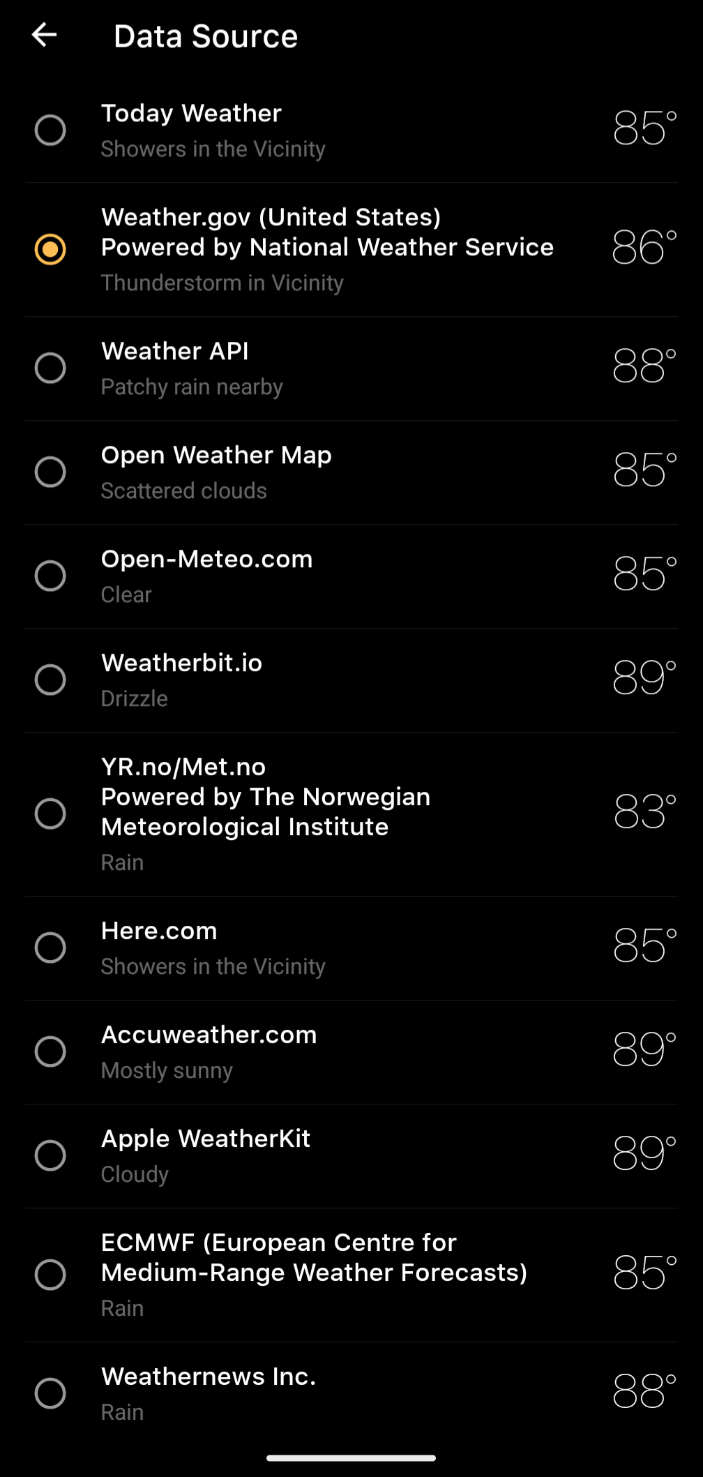
I just looked at my weather app (Today Weather), and the report of the current temperature varies by 6°F depending on which data set I choose. I go with the National Weather Service (federal govt).

As far as predicting precipitation, the radar seems pretty good for the next few hours. I press play on it, and it tells me what it thinks the radar will look like for the next 7 hours in 15 mins increments.

I think that predicting the weather beyond a day gets pretty difficult because the weather is too chaotic. The best they can do is to gather data from local weather stations and see how often it rained when they had these same data in the past. So basically, it's like saying, "When the temp has been 85°F, humidity 62%, wind from WNW at 5 kts, pressure at 1016 mBar, and the date was July 29, it rained 6 times out of 10."

[-] crozilla@lemmy.world 2 points 3 months ago

MyRadar is scary good, in my experience.

[-] Audalin@lemmy.world 2 points 3 months ago

Because we have tons of ground-level sensors, but not a lot in the upper layers of the atmosphere, I think?

Why is this important? Weather processes are usually modelled as a set of differential equations, and you want to know the border conditions in order to solve them and obtain the state of the entire atmosphere. The atmosphere has two boundaries: the lower, which is the planet's surface, and the upper, which is where the atmosphere ends. And since we don't seem to have a lot of data from the upper layers, it reduces the quality of all predictions.

load more comments
view more: next ›
this post was submitted on 28 Jul 2024
182 points (93.3% liked)

No Stupid Questions

35681 readers
945 users here now

No such thing. Ask away!

!nostupidquestions is a community dedicated to being helpful and answering each others' questions on various topics.

The rules for posting and commenting, besides the rules defined here for lemmy.world, are as follows:

Rules (interactive)


Rule 1- All posts must be legitimate questions. All post titles must include a question.

All posts must be legitimate questions, and all post titles must include a question. Questions that are joke or trolling questions, memes, song lyrics as title, etc. are not allowed here. See Rule 6 for all exceptions.


Rule 2- Your question subject cannot be illegal or NSFW material.

Your question subject cannot be illegal or NSFW material. You will be warned first, banned second.


Rule 3- Do not seek mental, medical and professional help here.

Do not seek mental, medical and professional help here. Breaking this rule will not get you or your post removed, but it will put you at risk, and possibly in danger.


Rule 4- No self promotion or upvote-farming of any kind.

That's it.


Rule 5- No baiting or sealioning or promoting an agenda.

Questions which, instead of being of an innocuous nature, are specifically intended (based on reports and in the opinion of our crack moderation team) to bait users into ideological wars on charged political topics will be removed and the authors warned - or banned - depending on severity.


Rule 6- Regarding META posts and joke questions.

Provided it is about the community itself, you may post non-question posts using the [META] tag on your post title.

On fridays, you are allowed to post meme and troll questions, on the condition that it's in text format only, and conforms with our other rules. These posts MUST include the [NSQ Friday] tag in their title.

If you post a serious question on friday and are looking only for legitimate answers, then please include the [Serious] tag on your post. Irrelevant replies will then be removed by moderators.


Rule 7- You can't intentionally annoy, mock, or harass other members.

If you intentionally annoy, mock, harass, or discriminate against any individual member, you will be removed.

Likewise, if you are a member, sympathiser or a resemblant of a movement that is known to largely hate, mock, discriminate against, and/or want to take lives of a group of people, and you were provably vocal about your hate, then you will be banned on sight.


Rule 8- All comments should try to stay relevant to their parent content.


Rule 9- Reposts from other platforms are not allowed.

Let everyone have their own content.


Rule 10- Majority of bots aren't allowed to participate here.


Credits

Our breathtaking icon was bestowed upon us by @Cevilia!

The greatest banner of all time: by @TheOneWithTheHair!

founded 1 year ago
MODERATORS